Hike to Pointe de la Sambuy

I spent last summer (and more) in Annecy, in Haute-Savoie. I went back on a hike to Pointe de la Sambuy, in the Bauges mountains near Faverges (south of Annecy). This time, I took the standard trail to the summit.
I spent last summer (and more) in Annecy, in Haute-Savoie. I went back on a hike to Pointe de la Sambuy, in the Bauges mountains near Faverges (south of Annecy). This time, I took the standard trail to the summit.

Mount Royal (Mont Royal) is a small mountain in Montreal, immediately west of downtown. It is the site of Mount Royal Park, designed by Frederick Law Olmsted and the city’s largest park.
Above, Mount Royal seen from the observatory of Au Sommet Place Ville-Marie. The Belvédère Kondiaronk, on the left, offers a great view on the city. The Mount Royal Cross can be seen on the right.

Last winter, on Christmas day, I went to Col de la Faucille, in the French Jura near Geneva. There is a ski resort there but there was barely any snow. I took the ropeway to the summit of Mont Rond and walked around for a bit.

The Khewra Salt Mine is located in the Salt Range mountains in Punjab, Pakistan, between Lahore and Islamabad. It is Pakistan’s largest and oldest salt mine and the world’s second largest. It is said to have been discovered when horses in the army of Alexander the Great began licking the stones near the mine. It is now a major tourist attraction in the area.

For my last hike of the summer, I went to Mont Charvin, a mountain in the Aravis range located near Faverges. I followed this itinerary.

The Pic de Jallouvre is a mountain in the Bornes Massif located near Le Grand-Bornand in Haute-Savoie. I followed this itinerary (in the other direction; also I walked until the Col de la Colombière and the end diverges a bit as well), going on a loop around the Pic starting and ending at Le Grand-Bornand.

The Dents de Lanfon (Teeth of Lanfon) are a mountain in the Bornes Massif bordering Lake Annecy. There is a great view at the summit but the trail is quite difficult. I followed this itinerary.

This is the second part of the loop around Pointe Rousse des Chambres. Below are photos of the trail from the summit of Pointe de Bellegarde to Samoëns, passing through Lac de la Vogealle and Combe aux Puaires.

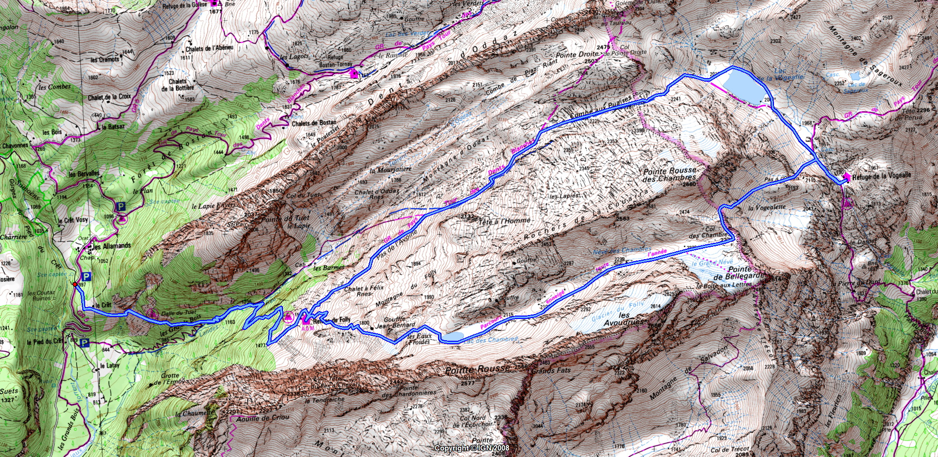
The Lac des Chambres, Pointe de Bellegarde and Lac de la Vogealle are located next to the Cirque du Fer à Cheval in the Massif du Giffre, in Haute-Savoie. They are points of interest on the Tour des Dents Blanches, which takes multiple days. For myself, I just went there for a day-hike walking a loop around the Pointe Rousse des Chambres, starting and ending in the village of Samoëns. The itinerary I followed was like this one (although in the other direction as the one described). Here is a map. Here is more detailed description of the trail until Lac de la Vogealle and some instructions to go up to Combe aux Puaires from there. In this post, I am posting photos from the part from Samoëns to the summit of Pointe de Bellegarde. I will post the rest in Part 2.
")
This is part 2 of the day-hike to Pointe d’Arcalod, Pointe de Chaurionde & Pointe de la Sambuy. After Col d’Orgeval, I basically followed this itinerary. Check the previous post for a map of the actual path I walked.
After getting down to Col d’Orgeval from Pointe d’Arcalod, I went up again on the other side to Pointe de Chaurionde, just as the sun was reappearing. From the summit, I could see up to Albertville and the Beaufortain. Still no Mont Blanc unfortunately… I then followed the ridge trail to Pointe de la Sambuy. Slightly before reaching the base of the Pointe, I left the ridge looking for the way up to the summit, a path that would involve rock-climbing the face of the Sambuy to the top. I saw some pink markers but I kept looking since the path they indicated was looking more difficult than what I had read. It was the correct way however… It turned out it was not that hard even though the rocks were not very solid, so I just had to be extra-careful. Finally, I arrived at the summit! I was the only one there. I then made my way down and, after a detour through the Petite Sambuy (Small Sambuy) below, I took the ski lift to the base of the Seythenex-Sambuy ski resort. There was a summer luge track so I spent a bit of time there. The next step was pretty tedious since I had to walk back to Faverges using the paved road. It took much longer than I had estimated and when I arrived at the village of Seythenex, I realized I would not make it in time for the last bus to Annecy. At that point, I started running, cutting through the woods at some point and then on the road that leads to Tamié. I arrived at the bus stop 15min late but, fortunately, so did the bus.