lake

Hiran Minar

Hiran Minar (Minaret of Antelope) is a Mughal site in Sheikhupura, Pakistan, near Lahore. Hiran Minar itself is a tower constructed by Mughal Emperor Jahangir as a monument to one of his pet deer. It is set next to an artificial square lake with an observation pavilion in the middle.
Hike to Mont Charvin

For my last hike of the summer, I went to Mont Charvin, a mountain in the Aravis range located near Faverges. I followed this itinerary.
Hike to Dents de Lanfon

The Dents de Lanfon (Teeth of Lanfon) are a mountain in the Bornes Massif bordering Lake Annecy. There is a great view at the summit but the trail is quite difficult. I followed this itinerary.
Hike to Lac des Chambres, Pointe de Bellegarde & Lac de la Vogealle (part 2)

This is the second part of the loop around Pointe Rousse des Chambres. Below are photos of the trail from the summit of Pointe de Bellegarde to Samoëns, passing through Lac de la Vogealle and Combe aux Puaires.
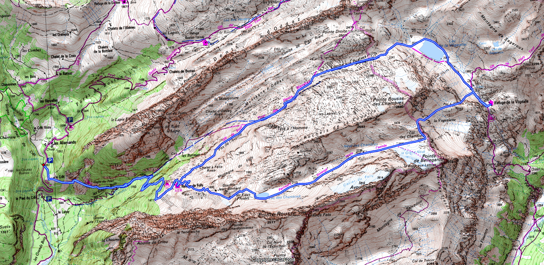
Hike to Lac des Chambres, Pointe de Bellegarde & Lac de la Vogealle (part 1)

The Lac des Chambres, Pointe de Bellegarde and Lac de la Vogealle are located next to the Cirque du Fer à Cheval in the Massif du Giffre, in Haute-Savoie. They are points of interest on the Tour des Dents Blanches, which takes multiple days. For myself, I just went there for a day-hike walking a loop around the Pointe Rousse des Chambres, starting and ending in the village of Samoëns. The itinerary I followed was like this one (although in the other direction as the one described). Here is a map. Here is more detailed description of the trail until Lac de la Vogealle and some instructions to go up to Combe aux Puaires from there. In this post, I am posting photos from the part from Samoëns to the summit of Pointe de Bellegarde. I will post the rest in Part 2.
Hike from Plan de la Lai to Col des Fours & Ville des Glaciers

The hike from Plan de la Lai to Ville des Glaciers was one of the best hikes I did this summer. It starts at the Refuge du Plan de la Lai, between Beaufort and Bourg Saint-Maurice, in the Beaufortain. It then goes through the Refuge de la Croix du Bonhomme, a usual stop on the Tour du Beaufourtain, then continues to Col des Fours, before finally going down to the Vallée des Glaciers. I basically followed this itinerary (with map), with a detour to Rocher du Vent and the Roches Merles at the beginning and through the Têtes Nord and Sud des Fours near Col des Fours.
Old Town of Annecy

The Old Town of Annecy (le Vieil Annecy) is the most visited part of the city. It is located at the mouth of the Thiou river, an effluent of Lake Annecy on the way to the Fier River. It mostly developed starting in the 13th century when Annecy became the capital of the County of Geneva. Its most famous sights are the Castle, the Palais de l’Ile (which served as a court and a jail) and the canals. It is a pedestrian-only area and is host to many restaurants and shops, as well as a large market every Sunday morning.
Along Lac du Bourget by bike

After getting back to Aix-les-Bains from Mont Revard, I took my bike on the Voie Verte du Lac du Bourget, a bike lane (actually shared with roller skaters and pedestrians) next to the lake. Lac du Bourget is the biggest lake in France and the bike lane only goes along a small part of its shore. When I arrived at Bourget-du-Lac at the southern shore of the lake, I took the Avenue Verte Nord de Chambéry, which is another separate bike lane that goes all the way to Chambéry.
Belvédère du Mont Revard

After the hike to Croix du Nivolet, I made a stop at the nearby Belvédère du Mont Revard. It is a viewpoint that provides a great view on the Lac du Bourget below and the surrounding mountains. I then took my bike down the mountain back to Aix-les-Bains.