Hike to Gorges de la Colonnaz & Mont Favy
Last fall, I went on hike above Magland: I walked up to Les Carroz through Gorges de la Colonnaz, visited Mont Favy, then looped back through Arâches.
Here is a map of the path I walked:
- Download path KML
- Download large map
- More photos on Flickr
- Day of the hike: September 30th, 2021
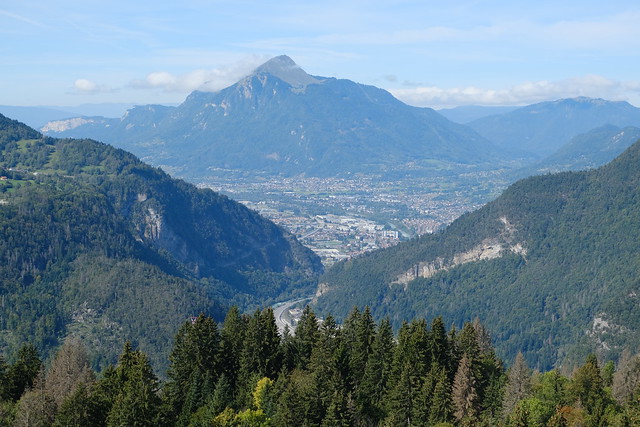
In the morning, I took the train to Magland, a small town between Cluses and Sallanches. I then walked to the entrance of Gorges de la Colonnaz. This is where Funiflaine (a cable car linking the valley and Flaine) is supposed to be built in the near future. The trail was quite steep and there were a couple of suspension bridges to cross Torrent de l’Épine. At some point, I forded the river and took a path below Rochers de la Porte in order to reach Les Carroz. It is a popular ski resort during winter and hiking resort during summer. However, when I was there in September, it was pretty much a dead town. I visited the local church, the modern Église Notre-Dame-de-l’Assomption, then found another trail in order to get to Mont Favy, the highest point of the day. It is a viewpoint with a good view on the Aravis mountains on the other side of the valley. Cluses and Le Môle could also be seen.
I ate lunch there then started on the way down. There were a few viewpoints along the way. Before reaching the village of Arâches-la-Frasse, I maded a detour to Pierre à Laya, a glacial erratic. After Arâches, I went down to the hamlet of Balme, near the Arve river. However, there is no path along the river because of the train track (there is a level crossing and after that a bicycle bridge can be used to cross the river, but that path passes through a quarry and, since it was a weekday, there were probably people working). Instead, I had to walk on the side of the road for ~30 min. There was a lot of car traffic so that part was not great at all. At some point, I took a secondary road in order to get back to the Magland train station.
▲ Magland train station.
▲ Cliff above Magland. The path I walked passed along the top.
▲ Rochers de la Maladière.
▲ Fog.
▲ Torrent de l’Épine.
▲ Start of the path up the Gorges de la Colonnaz.
▲ Suspension bridge.
▲ Looking down towards the valley.
▲ Pointe d’Areu on the other side of the valley.
▲ Ford.
▲ Below Rochers de la Porte.
▲ Les Quatre Têtes.
▲ Bridge across the Arve river.
▲ Arve (in light blue) and a lake.
▲ Highway to Tunnel du Mont Blanc and Italy.
▲ I made a detour from the main trail to a few viewpoints.
▲ Église Saint-Maurice in Magland.
▲ Pointe d’Areu.
▲ Les Carroz.
▲ Église Notre-Dame-de-l’Assomption.
▲ Out of season.
▲ Inside Église Notre-Dame-de-l’Assomption.
▲ Aiguille d’Aujon, above Flaine.
▲ Aravis.
▲ Mont Favy.
▲ Pointe d’Areu in the Aravis.
▲ Towards Cluses.
▲ Pointe de Marcelly.
▲ Cluses.
▲ Pointe des Brasses.
▲ Tête du Château.
▲ Highway.
▲ Le Môle.
▲ Tête de la Sallaz.
▲ Horse on the narrow path.
▲ Arve.
▲ Another viewpoint.
▲ The northern extent of the Aravis mountains.
▲ Recently built bicycle bridge across the Arve.
▲ Pierre à Laya, a glacial erratic.
▲ Arriving at Arâches-la-Frasse.
▲ Église Saint-Michel.
▲ At Balme.
▲ Rochers de la Maladière.
▲ Walking on the side of the road.
▲ Train track.
▲ Entrance of Grotte de Balme.
▲ Level crossing.
▲ Mont Joly.
▲ Shrine.
▲ I made a detour to a bridge (Pont Rouge) across the Arve but I stayed on the right bank.
▲ One of the viewpoints I passed by earlier.
▲ Aiguille d’Aujon.
▲ Aravis.
▲ Tête de Louis-Philippe. Gorges de la Colonnaz is the crack next to the power transmission towers.
▲ Zoom on Gorges de la Colonnaz.
▲ Montagne de Chevran.
▲ Above the highway.
▲ Below the road I was just on.
▲ Église Saint-Maurice.
▲ Coat of arms of Magland. The strange symbol that looks like a stylized 4 is called Quatre de Chiffre.
▲ Back at the Magland train station.


