Snowshoe hike on Plateau de Beauregard & Frêtes de Colomban
In the winter of 2020, I went back to the ski resort of La Clusaz and went on a snowshoe hike on Plateau de Beauregard.
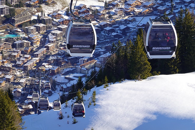
Here is a map of the path I walked:In the morning, I took a LIHSA bus (line 62) from Annecy to La Clusaz. I boarded a gondola at Télécabine de Beauregard to reach the plateau. There were quite a lot of people there. I walked the short path to the summit of Pointe de Beauregard, where I had already been in the summer. There was a great view. Then I followed prepared tracks for pedestrians and snowshoe hikers towards Col de la Croix Fry in Manigod. I took a wrong turn at some point and found myself on a slope for alpine skiing, so I had to get back up. Before reaching Col de la Croix Fry, I found a trail going up to the ridge of Frêtes de Colomban. Once I got out of the forest, there was a view of Plateau de Beauregard below and the surrounding mountains. Then, I went down towards Chalet de Colomban. In the morning, I had planned to make a detour to the cross nearby (Croix de Colomban) but I decided to play it safe and go back to the station of Télécabine de Beauregard before it closed. I crossed the Plateau and took a gondola down to the village then waited for the bus.
▲ Le Nom, which flows from Col des Aravis and joins with the Fier river in Thônes.
▲ At the lower station of Télécabine de Beauregard
▲ From the upper station.
▲ Montagne des Voirons in the distance.
▲ Mont Lachat de Thônes.
▲ Skiiers.
▲ Col des Aravis.
▲ South of Col des Aravis.
▲ Lounging chairs at the summit of Pointe de Beauregard.
▲ View from the summit: La Clusaz below, with Aravis on the right, Chaîne du Bargy on the left and Tête du Danay in the center.
▲ Pointe Percée.
▲ Mont Téret.
▲ Chaîne du Bargy, with Roc des Tours and Pic de Jallouvre.
▲ On the way down.
▲ Plateau de Beauregard. Chalet de Colomban is straight ahead on the photo.
▲ Dent du Cruet.
▲ Here I took a wrong turn. I realised mid-way, but on the map there looked like there was a dirt road to get back on track so I kept going. Unfortunately, during winter that dirt road becomes an alpine ski slope and I had to get all the way back up.
▲ Prepared track towards Col de la Croix Fry.
▲ Belvédère de l’Étale below Pointe de Merdassier.
▲ Mont Blanc peaking through Col des Aravis.
▲ Trail to Frêtes de Colomban. While until then, it would have been fine without snowshoe, there were more of a necessity on that part.
▲ Tête de Cabeau in Manigod.
▲ Mont Blanc.
▲ Col de la Croix Fry below.
▲ North part of the Aravis range.
▲ Crêt du Loup.
▲ Near the highest point of the Frêtes.
▲ Plateau de Beauregard below.
▲ Roc de Charmieux, Rocher de Salin and Rochers de Leschaux.
▲ Col de la Colombière in Le Grand-Bornand.
▲ Summit of Mont Lachat de Thônes.
▲ Mont Lachat de Châtillon, the highest point of the ski area of Le Grand-Bornand, and Pointe de Grande Combe and Pointe d’Almet on the right.
▲ Chaîne du Bargy.
▲ Pointe Percée.
▲ Pointe de Beauregard.
▲ Chalet de Colomban and Mont Téret behind it.
▲ Snowshoe hikers.
▲ On the way down.
▲ Chalet de Colomban.
▲ Dent du Cruet.
▲ La Tournette.
▲ Plateau de Beauregard seen from Chalet de Colomban.
▲ On the way down to the Plateau.
▲ Frêtes de Colomban above.
▲ Oratoire de Saint-Jacques.
▲ Pointe de Beauregard.
▲ Aiguille de Borderan and Mont Blanc.
▲ I walked off-trail to reach the Chalet.
▲ Col des Aravis.
▲ L’Étale.
▲ Le Grand-Bornand.
▲ Pointe de Merdassier.
▲ Chalet de Colomban.
▲ Pointe de Beauregard.
▲ Mont Charvin.
▲ Col des Aravis in shadow.
▲ West tip of Chaîne du Bargy.
▲ On the gondola to the village of La Clusaz.
▲ Waiting for the bus.


