New map styles from Stamen Design
I learnt today that Stamen Design have released new map styles for Open Street Map data. I really like the watercolor one, as it is quite different from what is usually seen on web maps.
I learnt today that Stamen Design have released new map styles for Open Street Map data. I really like the watercolor one, as it is quite different from what is usually seen on web maps.
Urban Sound Ecology is a research initiative dedicated to exploring, examining, and understanding the sonic spaces of Canadian cities. At once an archive, database, and creative remapping of the city, Urban Sound Ecology is free to join and free to use. We invite interested participants to construct lines of inquiry into the aural landscape of Canadian cities by producing sequences of geo-referenced ‘soundwalks. (more)
Very cool 8-bit map of New York City. More details about this project can be found here.

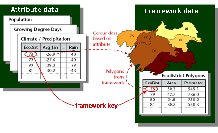
I have recently learned about an upcoming OGC standard that looks interesting: The Table Joining Service (formerly known as the Geographic Linkage Service or GLS). It standardizes a solution to the very common problem of mapping statistical data that is geographically related but maintained outside a GIS. To do that, the service uses a key (for example, a country or zip code) common to the statistical dataset and a geographic dataset providing the geometries.
I had been trying to get into iPhone / iPod Touch application development for some time, but I was just too lazy until I bought a few weeks ago an iPod Touch (which I really like - I am playing the Sudoku game from Mighty Mighty Good Games all the time).
The new version has been released a few days ago. There does not seem to be anything earth-shattering in the update, according to the release notes and my own experience with it. Just a few corrections here and there and more samples in the documentation. I have been using version 1.0 of the API since it got out of beta in October last year and I have enjoyed it very much. It may also have something to do with the fact Flex can be much less frustrating to work with than the HTML + JavaScript combo.
This tutorial will show how to use version 3.1 of the Calais API to identify geographic references in a text and display them on an OpenLayers map. I am going to use the Calais API with JSON output (which is a new feature of version 3.1), so that all the processing can be done easily in JavaScript entirely inside a web browser.
Street Views have now been added to some French cities, including Paris. The coverage there is pretty good, with parts of the suburbs as well as the main Paris city currently visible. The other cities include Lyon, Marseille, Lille, Nice and Toulouse.
Above, the Panthéon, in Paris.

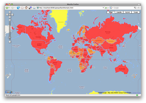
Google has recently released a Flash version of the Google Maps API. The goal is to give developers and designers more freedom in the presentation and graphical effects of their maps. Google is certainly not the first provider of a Flash mapping API (see the Yahoo! Maps AS3 API for example) but as one of the original proponents of Ajax web mapping tools, it marks an interesting change of direction (although the original Google Maps API is probably not going away anytime soon). One interesting aspect of using Flash is also a boost in vector graphics rendering speed, which I am going to demonstrate here, with a tutorial showing how to display a chloropleth map with this new API. Here is a link to the final application. It has to be noted that I am definitely not a Flex/ActionScript guru (just a few evenings of experience) so there are probably better ways of doing things than what I am showing here.