Hike to Dents de Lanfon

The Dents de Lanfon (Teeth of Lanfon) are a mountain in the Bornes Massif bordering Lake Annecy. There is a great view at the summit but the trail is quite difficult. I followed this itinerary.
The Dents de Lanfon (Teeth of Lanfon) are a mountain in the Bornes Massif bordering Lake Annecy. There is a great view at the summit but the trail is quite difficult. I followed this itinerary.

This is the second part of the loop around Pointe Rousse des Chambres. Below are photos of the trail from the summit of Pointe de Bellegarde to Samoëns, passing through Lac de la Vogealle and Combe aux Puaires.

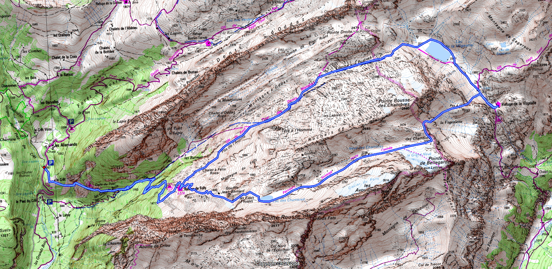
The Lac des Chambres, Pointe de Bellegarde and Lac de la Vogealle are located next to the Cirque du Fer à Cheval in the Massif du Giffre, in Haute-Savoie. They are points of interest on the Tour des Dents Blanches, which takes multiple days. For myself, I just went there for a day-hike walking a loop around the Pointe Rousse des Chambres, starting and ending in the village of Samoëns. The itinerary I followed was like this one (although in the other direction as the one described). Here is a map. Here is more detailed description of the trail until Lac de la Vogealle and some instructions to go up to Combe aux Puaires from there. In this post, I am posting photos from the part from Samoëns to the summit of Pointe de Bellegarde. I will post the rest in Part 2.
")
This is part 2 of the day-hike to Pointe d’Arcalod, Pointe de Chaurionde & Pointe de la Sambuy. After Col d’Orgeval, I basically followed this itinerary. Check the previous post for a map of the actual path I walked.
After getting down to Col d’Orgeval from Pointe d’Arcalod, I went up again on the other side to Pointe de Chaurionde, just as the sun was reappearing. From the summit, I could see up to Albertville and the Beaufortain. Still no Mont Blanc unfortunately… I then followed the ridge trail to Pointe de la Sambuy. Slightly before reaching the base of the Pointe, I left the ridge looking for the way up to the summit, a path that would involve rock-climbing the face of the Sambuy to the top. I saw some pink markers but I kept looking since the path they indicated was looking more difficult than what I had read. It was the correct way however… It turned out it was not that hard even though the rocks were not very solid, so I just had to be extra-careful. Finally, I arrived at the summit! I was the only one there. I then made my way down and, after a detour through the Petite Sambuy (Small Sambuy) below, I took the ski lift to the base of the Seythenex-Sambuy ski resort. There was a summer luge track so I spent a bit of time there. The next step was pretty tedious since I had to walk back to Faverges using the paved road. It took much longer than I had estimated and when I arrived at the village of Seythenex, I realized I would not make it in time for the last bus to Annecy. At that point, I started running, cutting through the woods at some point and then on the road that leads to Tamié. I arrived at the bus stop 15min late but, fortunately, so did the bus.
")
At 2217m, Pointe d’Arcalod is the highest peak in the Bauges Massif. The nearby Pointe de la Sambuy and Pointe de Chaurionde are respectively the 2nd and 5th highest. It is possible to climb them all on a single day-hike, in a loop starting and ending in Faverges. It makes for quite a long day though…

The hike from Plan de la Lai to Ville des Glaciers was one of the best hikes I did this summer. It starts at the Refuge du Plan de la Lai, between Beaufort and Bourg Saint-Maurice, in the Beaufortain. It then goes through the Refuge de la Croix du Bonhomme, a usual stop on the Tour du Beaufourtain, then continues to Col des Fours, before finally going down to the Vallée des Glaciers. I basically followed this itinerary (with map), with a detour to Rocher du Vent and the Roches Merles at the beginning and through the Têtes Nord and Sud des Fours near Col des Fours.
")
La Jonction (The Junction) is a rocky area below the Mont Blanc where the Glacier des Bossons and the Glacier de Taconnaz meet. The first successful ascent of the Mont Blanc by Jacques Balmat and Michel-Gabriel Paccard in 1786 was made through there: The hiking trail goes past the rock formation (known as Gîte à Balmat) where the 2 men stayed at some point during that ascent. I followed this itinerary.

During the summer, I took my bike on the SIBRA summer shuttle to the top of the Semnoz. My goal was go down to Lake Annecy using the paved road (there are tracks for downhill mountain bikes as well): It is an almost uninterrupted downward slope until the lake with relatively little car traffic. Before going down, I spent some time on the plateau, which serves as cross country skiing tracks during winter. I also went to the summit (Crêt de Châtillon). There was a good view on the Mont Blanc from up there. Finally, I took the road to Leschaux, then went down the Route du Col de Leschaux until I reached the lake at Sévrier.

At 2750m, Pointe Percée (Pierced Peak, so named because of this hole) is the highest peak in the Aravis range. It is also a very popular hike in the area, although it can be challenging. I followed this itinerary (Cheminées de Sallanches on the way up, standard trail on the way down).

The Croix du Nivolet is a giant christian cross (22 meters high) at the summit of the Dent du Nivolet, in the Bauges Massif. Its size and location make it highly visible from Chambéry and the surrounding towns. It offers a great view on the valley below, as well as the Lac du Bourget. The path to get there is pretty easy (although sometimes muddy) and is therefore very popular. This itinerary was the inspiration for the path I followed.