OGC Table Joining Service

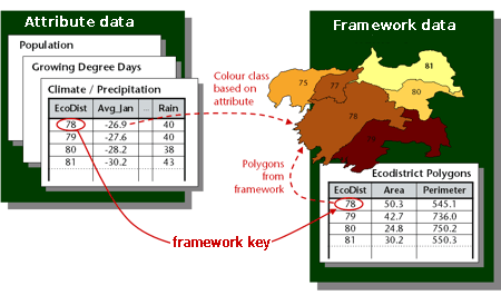
I have recently learned about an upcoming OGC standard that looks interesting: The Table Joining Service (formerly known as the Geographic Linkage Service or GLS). It standardizes a solution to the very common problem of mapping statistical data that is geographically related but maintained outside a GIS. To do that, the service uses a key (for example, a country or zip code) common to the statistical dataset and a geographic dataset providing the geometries.
The TJS has 2 kinds of operations:
- Data access operations: They allow the straight retrieval of statistical data in a XML format called GDAS (Geographic Data Attribute Set). One operation also provides metadata that can be used to generate suitable symbolizations automatically.
- Data joining operations: They allow the dynamic join of statistical and geographic datasets. A join query can also include SLD styling instructions. The output of the join operation is usually a custom WMS service that can be used to retrieve actual map images.
It is not yet an official standard (only a RFC has been published) but it should be adopted in the next few months.
There is already an implementation available (that was how I learned about it) in the Géoclip Server product. The publisher has a page with some more details on TJS, as well as a demo application (click on the
![]()
icon at the top to access a TJS).